Metrolink
 A Metrolink train in tram mode, running below Piccadilly Station (image CC-BY.2.0; attribution details and original)
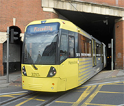
 Metrolink is Manchester’s unique system of hybrid ‘tram-trains’ for urban transit.
Across part of the city centre, Metrolink trains operate as trams (known variously as streetcars or trolley-buses in other parts of the world), running in grooves along the street. As they move outside this area, they switch seamlessly to running on track as conventional light-rail passenger trains. (To local people, however, a Metrolink train is ‘a tram’, however it runs.)
- Metrolink home page
- Metrolink route map as a pdf
- Geographic map of the Metrolink network (very useful!)
The Metrolink network does NOT cover the University area or Oxford Road Station. The nearest station is at St Peter’s Square, by Manchester Town Hall, 1.5 km (15 to 20-minute walk) from University Place. Connections between the University and the city centre are mainly by bus.
However, all of our recommended city-centre hotels are within easy reach of a Metrolink station.
Metrolink provides convenient links between locations including
- Piccadilly rail station (Metrolink station: Piccadilly, downstairs at the Fairfield Street exit of the rail station near Platforms 10-14)
- Piccadilly Gardens bus station, for buses to the University (Metrolink station: Piccadilly Gardens)
- Victoria rail station, the medieval quarter including Chetham’s Library, and the National Football Museum (Metrolink station: Victoria)
- Castlefield urban heritage park and the Museum of Science and Industry (station: Deansgate-Castlefield)
- Salford Quays, including the Lowry gallery and theatre, and the Imperial War Museum North (station: either Harbour City or Media City UK)
- Manchester United Football Club (station: Old Trafford; alternatively, Exchange Quay on the Salford Quays side is only a 10-minute walk)
- and suburbs including Chorlton, West Didsbury and Didsbury Village – good for restaurants! (stations: Chorlton, Burton Road, Didsbury Village).